Let's not repeat old errors.
The following is, as you may know, the map I originally made for RTR7.
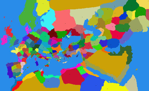
At the time I was rather foolish and naive and I thought the team generally knew what they were doing, and me as well. They did not, and neither did I. This is a very poor map design. When RTR was reformed under MCM, I made damn sure this map was ditched (though still TIC used a part of it).
The main problem? It's criminally imbalanced region wise and even then it does not make optimal use of the hardcoded limits on map extents.
At first glance, the tilt is appealing because it cuts out "dead space" in the north and south. However, considering how starved for space we were in the Mediterranean and especiall Greece, we should course put the longest axis of the map along the diagonal. This tilted projection throws away 1/3 of your resolution just to get rid of dead space that doesn't actually do much harm. Secondly, wait for it..................yeah, this is a Hotine, or oblique Mercator, projection. And as I mentioned before, that too is rather stupid, because resolution actually increases away from the center line, which is AWAY FROM THE AREA OF INTEREST! That is, the projection makes the small regions along the center line smaller, and the big ones away from it bigger! Let's not make a mistake we made and learned from (as a team) 10 years ago?